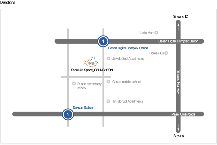
Seoul Art Spaces_GEUMCHEON
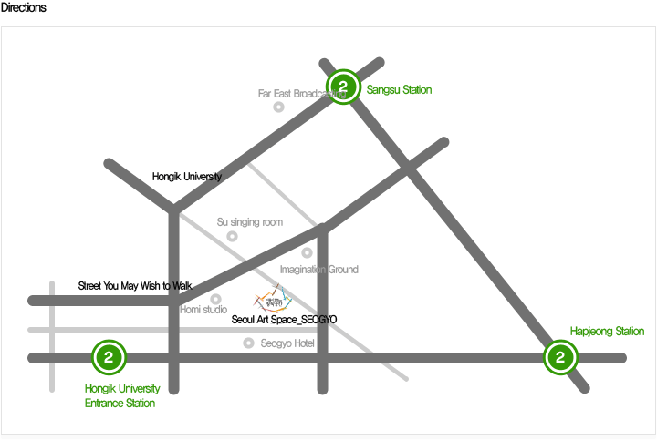
Posted: March 10th, 2010 | Author: nat | Filed under: Uncategorized | No Comments »Seoul Art Spaces_SEOGYO
Posted: March 10th, 2010 | Author: nat | Filed under: Uncategorized | Tags: seoul art space seogyo | No Comments »Cheonggyecheon
Posted: March 5th, 2010 | Author: nat | Filed under: Uncategorized | Tags: seoul pristine stream cheonggyecheon history | 1 Comment »Â History
The Cheonggyecheon used to be a naturally formed stream before the Joseon Dynasty designated Seoul as its capital. As the city had always been surrounded by mountains, its water was flowing into downtown. Because of the influence of the monsoon weather, it was dried in spring and fall, and warm and humid in summer.
Thus, the stream remained dry in fall and spring, but was likely to get flooded during rainy days in summer. There were many houses and shops along the stream flowing across downtown. On many occasions, heavy rain in summertime caused flood, with houses getting inundated and bridges getting damaged, and many casualties.
Thus, the Joseon Dynasty rulers attached a particular importance in the construction of a drainage system as part of the refurbishment project for the city. During the reign of King Taejong, the third king of the Joseon Dynasty, the work for overhauling the Cheonggyecheon was on his first priorities. The work, which had been carried out for two years from 1406, included dredging and bolstering the banks on both sides of the stream.
In 1411, a temporary authority named “Gaecheondogam” was set up to take care of the task of overhauling the stream. Early in the following year, work was carried out on a large scale for a month, involving a total of 52,800 men per day. The work included stone embankment for the mainstream and building up some stone bridges like Gwangtonggyo and Hyejeonggyo.
During the reign of King Taejong, overhauling the main stream had been the main focus. In contrast, a lot of efforts had been made to overhaul tributaries and streamlets during the reign of King Sejong, the fourth king of the dynasty, to prevent floods in downtown Seoul.
In 1441, an underwater column (called Supyo in Korean), marked with notches, was set up in the west side of Majeongyo (Bridge) to measure the water level in an effort against floods.
During the reign of King Sejong, the Cheonggyecheon was recognized as an important achievement for people’s everyday life. When Seoul was designated as the capital of the Joseon Dynasty, the theory of the configuration of the ground (“Pungsu” in Korean) came to birth: the Hangang (River) flowed from east to west along the outer boundary, while the Cheonggyecheon flowed from west to east into downtown.
At that time, there were no particular drainage systems. Thus, trash and wastewater flowed into the Cheonggyecheon in downtown Seoul. There were some officials insisting on the importance of the stream relying on the theory of the configuration of the ground and thus it should remain clean, while some others were supporting a more realistic opinion supporting the idea of the stream as a drain for people. King Sejong leaned to the latter’s opinion. Thus, the stream came to act as drainage for people living in Seoul.
King Yeongjo, the 21st king of the Joseon Dynasty, was the one who put the biggest efforts into the overhauling of the stream in the post-King Sejong period.
It appeared that King Yeongjo was willing to get remembered as a great king taking care of the need for overhauling the stream, like Yu the Great of the Xia Dynasty and King Yangdi of the Sui Dynasty of China, who used to get to be known for their greatest achievements in improving dramatically the management of the river along with their flood control projects.
For about half a century and until King Yeongjo came to the throne, after the changes made by Kings Taejong and Sejong, the stream saw no drastic change. Its capability remained sufficient to carry out household wastewaters from around 100,000 Seoulites.
However, the situation changed during the 17th and 18th Centuries. After the Japanese invasion in 1592 and the Manchu War in 1636, the population of Seoul greatly increased with people swarming from every part o the nation: from 80,000 people in 1657 to 190,000 in 1669. Under such circumstances, the amount of wastewaters increased to an extent that could not get covered by
the existing stream.
The situation got even worse since people who had newly moved to Seoul cultivated vegetables on every single space on both sides of the stream, causing some big drainage issues.
They were also using a lot of trees from the mountains as the main source of heat. Earth and sand coming from the bare mountains surrounding Seoul came to fill up the stream.
By 1725, when King Yeongjo came to the throne, the Cheonggyecheon was filled up by the ground and the sand swept from the mountains. The king established
“Juncheonsa (an office in charge of dredging streams)” in October 1759 after analyzing the situation on several
occasions.
The newly established office started with its dredging work in February 1760, dividing the main stream and its tributaries into a total of eight zones and fixing the damaged bridges. The work included overhauling
water channels in all royal palaces.
The work continued for 57 days, mobilizing a total of 200,000 men per day. In June 1773, retaining walls were made on both sides of the Cheonggyecheon, and curved courses became straight ones, with the work carried out in three different sectors.
During the Japanese colonial period, the Cheonggyecheon went through some changes different from those made in the past. First of all, it came to get called “Cheonggye” as it is called today, supposedly from 1914, when the colonialists rearranged stream names in Korea.
In the past five centuries during the Joseon Dynasty, it was just called “Gaecheon (meaning a stream).” Looking at the newspapers published during that time, the name “Gaecheon” rarely appeared from about 1916, apparently giving its way to the “Cheonggyecheon.”
The stream used to be the border between Bukchon and Namchon of the capital during the Joseon Dynasty. During the Japanese colonial period, the stream came to act as the border between Jongno regarded as the street for Koreans and Honmachi (referring to present Chungmuro), a Japanese town. The Japanese colonialists nicknamed the stream Dirty Stream by derision, instead of Cheonggyecheon (literally meaning a “Clean Stream”).
From around 1918, the colonialists started overhauling the stream in connection with their plan to establish the central institutions to rule the colony, including Joseon Government-General, north of the stream.
In the post-1920s period, the colonialists announced their plans to cover up the stream on several occasions, including one announced in 1926 to form a 10,000-pyeong (= 8 acre) housing site, one announced in 1935 to build up a road and an elevated railroad, one announced in 1939 regarding exclusively cars, and one announced in 1940 to build up a streetcar path along with a subway. Such plans were intended to solidify the colonial rule over Korea and develop Seoul as a supply base for the wars that the colonialists were waging against the U.S. and China, including the Pacific War.
However, with the exception of the Taepyeongno-Mugyodong section, which had been covered up in 1937, all those plans could never come true due to the lack of financial resources. The work for overhauling the stream caused many changes to the structures though. Due to the installation of a streetcar path nearby, Gwangtonggyo(Bridge) had been reinforced and expanded.
Next to the abutment of the bridge, sewage pipes exceeding 1 meter in diameter were buried. In 1908, Ogansumun, a landmark penstock, was completely dismantled to give its way to a bridge and a street. Several bridges, including Haranggyo and Yeongdogyo, were rebuilt.
By 1945, when the nation was liberated from the Japanese colonial rules, the Cheonggyecheon was filled up with trash,
ground and sand swept from the bare mountains and severely contaminated with wastes from shabby makeshift houses built alongside. After the Korean War (1950~1953), even more people swarmed into Seoul to find their way and make their living and settled down along the stream.
Those living in houses near the stream suffered a lot due to the stench caused by the large amount of wastes flowing into the stream. Thus, the image of Seoul had also been severely affected.
It appeared that the handiest way to put an end to the multitude of shabby, makeshift houses and the dirty smell was to cover up the
stream with concrete. Finally, the work to cover it up with concrete
started as quickly as possible by August 1958, with the 136m section
near Gwangtonggyo completed in 1955 ahead of the remaining
sections.
In addition, a 5.6 km-long, 16 m-wide elevated highway extending
from Gwanggyo to Majang-dong was completed over the stream in
August 1971 after four working years. Thus, all makeshift houses
along the stream were demolished, freeing the place for some modern
commercial buildings.
A multitude of large and small tool, lighting, shoes, clothes, secondhand book stores were opened one after another along the concrete-covered stream, attracting some endless lines of customers. Every day there were hundreds of thousands of vehicles passing through the covered stream and the elevated highway. The area eventually became the busiest and noisiest sector in Seoul. No other area in Seoul can reflect the city’s history of the past half-century better than the Cheonggycheon area, though.
By the end of the 1950s, it became a symbol of poverty and slovenliness, being filled up with trash and wastes. During the 1960s and 1970s, it was regarded as an example of successful industrialization and modernization. Then, in the 1980s and 1990s, it came to be regarded as a source of intense traffic, health and environmental issues.
Text by http://www.sisul.or.kr/grobal/cheonggye/eng/WebContent/index.html
Gwanghwamun Square
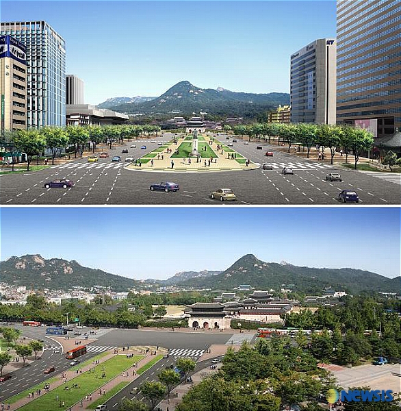
Posted: March 3rd, 2010 | Author: nat | Filed under: news, square | Tags: gwnghwamun, square | No Comments »The new Gwanghwamun Square at the heart of Seoul opens today(Aug 1) with a variety of exhibits and monuments showcasing the capital`s six-century history. The landmark square was established after a 15-month facelift of Sejongno, Seoul`s main thoroughfare. The square is located in front of Gwanghwamun, the main gate of Gyeongbok Palace, the key royal palace of the Joseon Dynasty (1392-1910)..
The public plaza, which is 34 meters wide and 557 meters long, was created as part of plans to refurbish Seoul`s main streets with cultural charms, green landscape and historic symbols. At the hall, a number of sculptures, models and pictures of Haechi are on display to familiarize citizens and visitors with the symbolic icon of Seoul. Haechi is a lion-like horned creature appearing in Korean myths as a guardian against fire and disasters. The stratigraphic layers of the Street of the Six Ministries, which were excavated in September last year, are also on display in the hall, offering a glimpse of the architectural skills and techniques of the Joseon Dynasty. The street was where key government agencies were located during the dynasty. Various facilities for the disabled, such as an elevator, escalators and disabled toilets are set at the hall. For easy wheelchair access, the path leading to the square from the underground hall has a gentle wide ramp.
On the way out of Haechi Madang, “Haechi Board,” a wide screen measuring 2 meters in length and 5 meters in width, is set on the right side of the wall.
Major sports events will be shown on the high-resolution screen, which will bring citizens together and make the square another gathering ground for enthusiastic supporters, officials said. The screen will also be used by couples who want to publicly express their love.
Right outside Haechi Madang, visitors can enjoy a wide view of Mount Bukak, which stands behind Gyeongbok Palace whose main gate is Gwanghwamun. The landmark gate is currently undergoing restoration work, which is scheduled to be completed by October next year.
Right above Haechi Madang, there is a statue of Yi Sun-shin (1545-1598), considered to be Korea`s greatest admiral. In front of the statue, 364 water jets are installed to demonstrate naval battles Yi successfully led against foreign invaders. LED lighting will illuminate fountains in front of the statue.
On the eastern and western edges of the square, there are “Waterways of History.” Each measures 2 centimeters in depth, 1 meter in width and 365 meters in length.
Key historical events that have happened since 1392, when the Joseon Dynasty was established, are engraved on the stone floor of the waterway on the eastern edge of the square. The floor of the waterway on the western edge is left empty so it can be updated in the future.
About 250 meters north of the statue of Admiral Yi, there will stand a statue of King Sejong (1397-1450), the inventor of the Korean alphabet, Hangeul. Professor Kim Young-won of Hongik University has been working on the statue, which will be unveiled on Hangeul Day (Oct. 9.)
In front of the statue, a water clock, a sundial, a rainfall gauge and a celestial globe are set. In the underground passage right under the statue, there will be an exhibition hall, which will enable visitors to take a closer look at the life and achievements of King Sejong. The hall will also be unveiled on Hangeul Day.
There will also stand a statue of Haechi near the northern end of the square. In front of Gwanghwamun, a large-scale “flower carpet” will be put in to celebrate the opening of the square.
The carpet, which is 17.5 meters wide and 165 meters long, is made of 224,537 flowers. The number matches the number of the days between Oct. 28 1394, when the capital of the Joseon Dynasty was transferred to Seoul from Gaeseong, the capital of the Goryeo Dynasty (918-1392), and today.
The beautiful flower arrangements can be enjoyed all year round, officials said.
With the opening of the square, concerns have been raised that the square could turn into a staging ground for massive anti-government protests. As the square is located near the presidential office, some say rules strictly governing the use of the square should be established.Â
(sshluck@heraldm.com)Â By Song Sang-ho
Text from
http://media.daum.net/foreign/englishnews/view.html?cateid=1047&newsid=20090801080045112&p=koreaherald
Dongdaemun Design Plaza
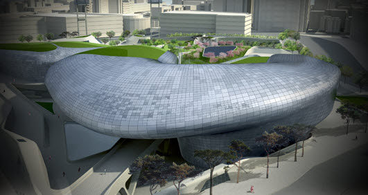
Posted: March 3rd, 2010 | Author: nat | Filed under: architecture | Tags: design, dongdaemun | No Comments »Design Plaza: comprehensive specialized facilities for the support of the design industry
- Covering an area of 83,000㎡ (including the underground cultural plaza), the Design Plaza will be equipped with a multi-purpose exhibition and convention hall, a design exhibition hall, an information training center, a learning center, a digital archive, a museum, and a design and media lab, as well as other facilities.
- The Design Plaza will be a global mecca for creative design by holding international design exhibitions and conferences, building a design network for cooperation at home and abroad, and running various support programs for creative design and marketing.
- It will host the Dongdaemun fashion industry by building and operating a fashion map and supporting marketing, production, and training.
- Development of an underground cultural plaza
The project will connect the trade area divided into the east and the west with Heunginmun-ro in the middle through the basement for the integration of the area and build an underground pedestrian network linked to the pedestrian underpass in Euljiro and subway stations of lines 2, 4, and 5, improving the pedestrian environment on the ground. Connected to the DDP structurally and functionally, the underground cultural plaza will serve as a high-class site for various cultural activities including exhibition and performance.
Text from  http://ddp.seoul.go.kr/eng/
ECC by Dominique Perrault
Posted: March 3rd, 2010 | Author: nat | Filed under: architecture | Tags: architecture | No Comments »
Dominique Perrault completed the campus center for Ewha University in Seoul, Korea. The new ‘campus valley’ provides both Ewhaians and prospective female students with much-needed space for continuing education and student services.
Further project description after the break.
The center, which began with a design competition in 2004, includes standard programmatic elements such as classrooms, administrative offices, libraries and a cafeteria. Â The 20,000 square meter project also includes a unique commercial space, featuring a theater and retail stores.
As is customary of Perrault’s work, the campus center’s spaces are interspersed above and below the land, allowing the structure to explore the mingling of constructed material with earth. The campus center manages to fit into its contained site by submerging much of the spaces underground.  Light penetrates the structure through a large channel that sits between the building’s two halves.
The campus center is designed to offer a new sense of direction for higher education in the 21st century. Â It will establish organic relations between the building and surrounding areas of campus as well as between above ground and below ground spaces
Text from http://www.archdaily.com/23813/ewha-univeristys-campus-center-dominique-perrault/
